Let us Guide you in the Past
by Ioannis Papastergiou – official licenced guide in Akrotiri
The Bronze Age settlement of Akrotiri in Thira was one of the most important Minoan urban centres and ports in the Aegean Sea when it was covered by volcanic ash in the 17th century BC.
Akrotiri, a prehistoric settlement on the island of Santorini (Thra), is one of the most prominent Aegean monuments. It was a well-connected Minoan port town in antiquity, with ties to mainland Greece as well as Egypt and Syria. Because the town was blanketed in ash after the island’s volcanic explosion, the settlement has been well preserved, making it one of Greece’s most important archaeological monuments.
Today, a bioclimatic roof covers the site, and walkways are suspended over the archaeological ruins, allowing visitors to wander between the two and three-story structures.
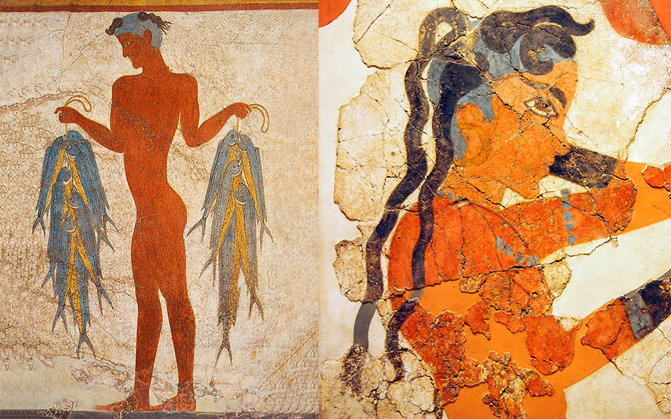
Did you know? Because the location was covered in volcanic ash, Akrotiri is known as the “Aegean Pompeii.” Archaeologists also discovered a burnt bed, similar to its Italian namesake. The Akrotiri of Thera Room of the National Archaeological Museum in Athens houses this, as well as a number of frescoes and other artifacts.
Although the oldest evidence of human occupation dates from the Late Neolithic (about 6,000 years ago), Akrotiri did not evolve into one of the Aegean Sea’s major urban centers and ports until the Late Bronze Age (approximately 4,000 years ago). The settlement covers an estimated 20 hectares, though not all of it has been discovered.
The settlement possessed a number of distinguishing features, including an extensive drainage system and sophisticated multi-story structures with stunning wall-paintings. The furniture and pottery utensils are of high quality and quantity, indicating the town’s prosperity. Whereas archaeologists have discovered several imported artefacts that point to a vast network of communication stretching across the Mediterranean, from Crete and the Dodecanese islands to mainland Greece, and from Cyprus to Egypt and Syria.
After a series of devastating earthquakes, the residents of the settlement were compelled to abandon the island in the end of the 17th century BC. A volcanic eruption followed (approximately in the year 1612 B.C.), with the ash totally covering the island and town. Although the exact date of the eruption is disputed (see this article in Science Advances for the latest study), it is widely agreed that it was the greatest volcanic eruption in the last 4,000 years.
WHERE IS AKROTIRI
The archaeological site of Akrotiri is directly south of the modern-day village with the same name, at the south-western part of the crescent shaped island of Thíra, the largest island in the Santorini archipelago.
HOW TO SEE AKROTIRI? BY PRIVATE GUIDED TOUR
The best way to discover Akrotiri is by booking a private guided tour, provided by a licenced tour guide. By following your guide’s narration is possible for you to revive images of the prehistoric settlement in your mind, unterstand its greatness and maybe fill the tragedy of all it’s great people as they were leaving their city in haste.
MAP OF AKROTIRI

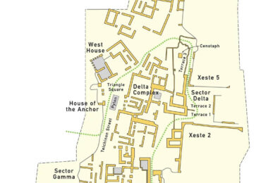
This map of shows the archaeological site of Akrotiri today, the extent of the site and how much has been excavated. The dotted green line shows the route of the Visitor Path through the site.
Of the frescoes in the National Archaeological Museum in Athens: The Spring Fresco was found in the Delta Complex building (the greyed infill room under the letter x on the map), while the boxers and the antelope frescoes were found in Sector Beta.
Check also our Private Guided Tours in Akrotiri archeaological site.
